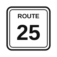
Guide sign · MUTCD M1-5
State Route Marker
This sign marks a state-numbered highway maintained by the state. The number identifies the route within that state.
- Shape
- Varies by state (often a square, circle or state outline)
- Color
- White with black border and black numerals
What to do
Use it to confirm you are on the right road and to navigate with your map or GPS. State routes may be two-lane roads with cross traffic and local speed limits, so watch posted signs and drive accordingly.
Where you see it
Along the highway and at junctions with other routes, and on guide signs.
Test trap
The exact shape differs from state to state, so the test relies on color: black numerals on white means a U.S. or state route, while blue and red means an Interstate. Do not assume a state route is a freeway.
Memory tip: Black on white and numbered by the state: a state route.
Practice question
This sign means:
- An Interstate highway
- A U.S. numbered route
- A state-numbered route
- A bike route
Answer: C. A route marker with black numbers on white identifies a state route.
DC DMV Driver Manual, p. 56